


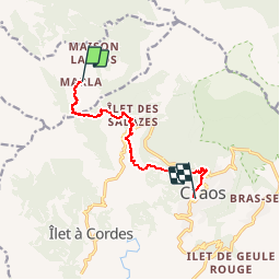
Marla - Cilaos

ARVIEU
User

Length
12.1 km

Max alt
2075 m

Uphill gradient
878 m
Km-Effort
25 km

Min alt
904 m

Downhill gradient
1289 m
Boucle
No
Creation date :
2019-01-15 18:27:52.947
Updated on :
2019-01-15 18:27:52.947
5h00
Difficulty : Difficult

FREE GPS app for hiking
 SityTrail
IGN / Geographical institutes
SityTrail Plus
The world is yours!
About
Trail Walking of 12.1 km to be discovered at Réunion, Unknown, La Possession. This trail is proposed by ARVIEU.
Description
Montée raide vers la col de Taïbit puis descente longue et pentue vers la Cascade du Bras Rouge et remontée vers Cilaos
Positioning
Country:
France
Region :
Réunion
Department/Province :
Unknown
Municipality :
La Possession
Location:
Unknown
Start:(Dec)
Start:(UTM)
337410 ; 7665608 (40K) S.
Comments